Вы не зашли.
- Форум
- » Средиземное море
- » Дарданелльская операция
#26 09.06.2011 17:37:44
- Geomorfolog
- Вице-Адмиралъ, картографъ, лучший меценат Форума 2009 и 2011

- Откуда: г. Ноябрьск-Белая Церковь
- Сообщений: 9530
Re: Дарданелльская операция
Aux Dardanelles la flotte des alliés fait sauter un navire qui gênait la navigation : [photographie de presse] / [Agence Rol] --1915

Насколько я понял взрыв корабля "мешпющего навигации"
Добро — это когда я украду чужой скот и чужих жен, а зло — когда у меня украдут.

#27 18.06.2011 21:31:34
- Geomorfolog
- Вице-Адмиралъ, картографъ, лучший меценат Форума 2009 и 2011
- Откуда: г. Ноябрьск-Белая Церковь
- Сообщений: 9530
Re: Дарданелльская операция
A bord du HMS Canopus, effet d'un canon de 12 pouces sur les batteries turques : [photographie de presse] 
Добро — это когда я украду чужой скот и чужих жен, а зло — когда у меня украдут.
#28 16.07.2011 20:50:24
- Strannik4465
- Адмиралъ


- Сообщений: 43265
Re: Дарданелльская операция
 =Десант в Дарданелах=
REMEMBER THE GOOD OLD NAVY
#29 24.08.2011 15:35:22
- Петрович
- Капитанъ II ранга

- Откуда: Киев
- Сообщений: 6857
Re: Дарданелльская операция
Да, а эвакуация у них проходила тоже не менее организованно и, что интересно, с использованием специально построенных десантных барж для перевозки войск с транспортов на берег-правда, возить войска им пришлось в обратном направлении, с берега на транспорты.
#30 15.09.2011 15:22:27
- Geomorfolog
- Вице-Адмиралъ, картографъ, лучший меценат Форума 2009 и 2011
- Откуда: г. Ноябрьск-Белая Церковь
- Сообщений: 9530
Re: Дарданелльская операция

Турецкие батареи и монные поля в изображении австралийцев.
Добро — это когда я украду чужой скот и чужих жен, а зло — когда у меня украдут.
#31 05.12.2011 17:34:49
- Geomorfolog
- Вице-Адмиралъ, картографъ, лучший меценат Форума 2009 и 2011
- Откуда: г. Ноябрьск-Белая Церковь
- Сообщений: 9530
Re: Дарданелльская операция
 Cannon, Dardanelles Expedition, No 1 Fort demolished by HMS Queen Elizabeth
Добро — это когда я украду чужой скот и чужих жен, а зло — когда у меня украдут.
#32 11.12.2011 14:39:12
- komo78
- Лейтенантъ

- Сообщений: 1088
Re: Дарданелльская операция
Понять не могу что за ствол, 15см\35 или 21см\35, или вообще что то другое.
#33 16.12.2011 20:24:52
- Geomorfolog
- Вице-Адмиралъ, картографъ, лучший меценат Форума 2009 и 2011
- Откуда: г. Ноябрьск-Белая Церковь
- Сообщений: 9530
Re: Дарданелльская операция

вот такая рельефная карта п-ова Галлиполи,1915г
Добро — это когда я украду чужой скот и чужих жен, а зло — когда у меня украдут.
#34 18.12.2011 21:59:49
- Geomorfolog
- Вице-Адмиралъ, картографъ, лучший меценат Форума 2009 и 2011
- Откуда: г. Ноябрьск-Белая Церковь
- Сообщений: 9530
Re: Дарданелльская операция
Short Type 184 torpedo plane. Was the first seaplane that a ship sank. The first victim was a Turkish ship in the sea of Marmora 08/11/1915
Интересно,это монтаж или нет?
Добро — это когда я украду чужой скот и чужих жен, а зло — когда у меня украдут.
#35 08.02.2012 09:24:50
- Geomorfolog
- Вице-Адмиралъ, картографъ, лучший меценат Форума 2009 и 2011
- Откуда: г. Ноябрьск-Белая Церковь
- Сообщений: 9530
Re: Дарданелльская операция
komo78 написал:
Оригинальное сообщение #449482
Понять не могу что за ствол, 15см\35 или 21см\35, или вообще что то другое.

то же орудие в другом ракурсе
Добро — это когда я украду чужой скот и чужих жен, а зло — когда у меня украдут.
#36 14.04.2012 10:52:15
- Юрген
- Капитанъ I ранга


- Откуда: С-Петербург
- Сообщений: 9784
Re: Дарданелльская операция
Не совсем десант, но рядом...
#37 08.07.2012 19:16:49
- Geomorfolog
- Вице-Адмиралъ, картографъ, лучший меценат Форума 2009 и 2011
- Откуда: г. Ноябрьск-Белая Церковь
- Сообщений: 9530
Re: Дарданелльская операция
 Turkish gun destroyed at Gallipoli
Добро — это когда я украду чужой скот и чужих жен, а зло — когда у меня украдут.
#38 19.07.2012 20:12:51
- Geomorfolog
- Вице-Адмиралъ, картографъ, лучший меценат Форума 2009 и 2011
- Откуда: г. Ноябрьск-Белая Церковь
- Сообщений: 9530
Re: Дарданелльская операция
Creator: H.E.C. Robinson Ltd.
Title: Dardanelles, Sea of Marmara, Bosporus [cartographic material] / by H.E.C. Robinson, Sydney.
Scale: Scale [ca. 1:120,000]. (E 26011'15"-E 26052'55"/N 40039'41"-N 039058'50").
Publisher: Sydney : H.E.C. Robinson, [1920?]
Date: 1920
Material Type: Map
Physical Description: 1 map : col., mounted on linen ; 69 x 51 cm., on sheet 71 x 54 cm., folded in cover 21 x 13 cm.
Notes: Map of the Gallipoli Peninsula region showing railways, principal roads, forts and batteries, and heights in feet. Relief shown by hachures and spot heights.
Cover title: Map of the Dardanelles to accompany Anzac Memorial.
"K. Craigie, Delt."; Also available in an electronic version via the Internet at: http://nla.gov.au/nla.map-vn3071266
Subjects: World War, 1914-1918 -- Turkey -- Gallipoli Peninsula Region -- Maps.
Bosporus (Turkey) -- Maps.
Dardanelles Strait (Turkey) -- Maps.
Marmara, Sea of (Turkey) -- Maps.

Добро — это когда я украду чужой скот и чужих жен, а зло — когда у меня украдут.
#39 20.07.2012 00:06:26
#40 20.07.2012 11:29:45
- Geomorfolog
- Вице-Адмиралъ, картографъ, лучший меценат Форума 2009 и 2011
- Откуда: г. Ноябрьск-Белая Церковь
- Сообщений: 9530
Re: Дарданелльская операция
Евгений Пинак написал:
Оригинальное сообщение #563553
Красивая карта
еще одна
Creator: Egypt. Maslahat al-Misahah.
Title: Orographical map of the Dardanelles [cartographic material] : reduced from captured Turkish maps.
Scale: Scale 1: 50 000.
Publisher: Egypt : Survey Dept., 1915-
Date: 1915
Material Type: Map
Physical Description: 1 map : col. ; 119 x 83.5 cm.
Notes: Map 238 from Ferguson Collection.
Orographical map of the Dardanelles with relief shown by colour shading and contour lines. Has some descriptions of land quality and use and gives magnetic variation.
Also available in an electronic version via the Internet at: http://nla.gov.au/nla.map-f238
Subjects: World War, 1914-1918 -- Campaigns -- Turkey -- Gallipoli Peninsula -- Maps.
Dardanelles Strait (Turkey) -- Maps.

Отредактированно Geomorfolog (20.07.2012 11:30:25)
Добро — это когда я украду чужой скот и чужих жен, а зло — когда у меня украдут.
#41 20.07.2012 23:23:02
- Geomorfolog
- Вице-Адмиралъ, картографъ, лучший меценат Форума 2009 и 2011
- Откуда: г. Ноябрьск-Белая Церковь
- Сообщений: 9530
Re: Дарданелльская операция
Creator: W. & A. K. Johnston Limited.
Title: War map of the Dardanelles and Bosporus [cartographic material] / drawn by W & A. K. Johnston Ltd, Edinburgh and London.
Scale: Scale 1 : 570 240 or 9 miles to an inch.
Publisher: Melbourne : [Macmillan], [1914 or 1915] (Melbourne : Specialty Press)
Date: 1914 - 1915
Material Type: Map
Physical Description: 1 map : col. ; 41.7 x 55.4 cm. folded to 13.3 x 17.8 cm.
Notes: Insets: Locality map of Turkish Empire--Dardanelles forts--Bosporus with forts.
Map 3711 from Ferguson Collection.
On verso: W.& A. K. Johnston Limited, ... Edinburgh, Australasia: Macmillan & Co.,..Melbourne.
Political map of Turkey and Asia Minor from the Aegean Sea to the Black Sea, showing Turkish fortifications and communications.
Also available in an electronic version via the Internet at: http://nla.gov.au/nla.map-f913
Subjects: World War, 1914-1918 -- Campaigns -- Turkey -- Gallipoli Peninsula -- Maps.
Balkan Peninsula -- Maps.
Bosporus (Turkey) -- Maps.
Dardanelles Strait (Turkey) -- Maps.

Отредактированно Geomorfolog (20.07.2012 23:34:04)
Добро — это когда я украду чужой скот и чужих жен, а зло — когда у меня украдут.
#42 04.08.2012 09:27:54
- Geomorfolog
- Вице-Адмиралъ, картографъ, лучший меценат Форума 2009 и 2011
- Откуда: г. Ноябрьск-Белая Церковь
- Сообщений: 9530
Re: Дарданелльская операция
http://recordsearch.naa.gov.au/scripts/ … p?B=370880
1. Submarine AE2 - Report loss in operations at Dardanelles. 2. Notification to next-of-kin. Crew now held prisoners-of-war in Turkey. Enquiries by relatives re safety of personnel. 3. Payments, allotments, monthly allowances, etc 4. Report by CO Sub AE2 Lt Cdr Stoken re conduct of crew. (Abbrev. Nos 5-10 to follow)
481 481 страница!
Добро — это когда я украду чужой скот и чужих жен, а зло — когда у меня украдут.
#43 04.08.2012 09:33:39
- Geomorfolog
- Вице-Адмиралъ, картографъ, лучший меценат Форума 2009 и 2011
- Откуда: г. Ноябрьск-Белая Церковь
- Сообщений: 9530
Re: Дарданелльская операция
Photograph. The Gallant 3rd Battalion, 1st Infantry Brigade, A.I.F. (Our Boys of the Dardanelles). 
Добро — это когда я украду чужой скот и чужих жен, а зло — когда у меня украдут.
#44 09.08.2012 15:02:06
- Geomorfolog
- Вице-Адмиралъ, картографъ, лучший меценат Форума 2009 и 2011
- Откуда: г. Ноябрьск-Белая Церковь
- Сообщений: 9530
Re: Дарданелльская операция
В операции в Дарданеллах союзники использовали воздушные шары,запускаемые с кораблей. Был даже специальный корабль HMS Monica:
The Royal Navy Balloon ship HMS Monica (right) with transports, in the Aegean Sea, off Anzac. Note the observation balloon.
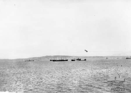
Отредактированно Geomorfolog (09.08.2012 15:04:06)
Добро — это когда я украду чужой скот и чужих жен, а зло — когда у меня украдут.
#45 09.08.2012 15:03:22
- Geomorfolog
- Вице-Адмиралъ, картографъ, лучший меценат Форума 2009 и 2011
- Откуда: г. Ноябрьск-Белая Церковь
- Сообщений: 9530
Re: Дарданелльская операция
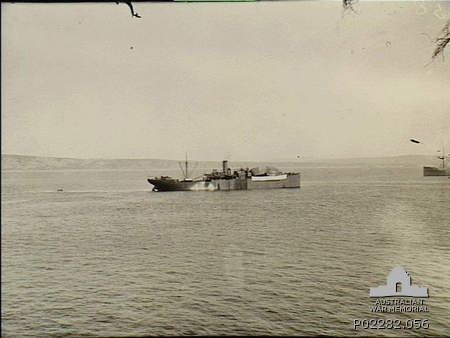
и
Gallipoli, Turkey, 1915. A Royal Navy balloon ship, possibly HMS Monica, stands off Gaba Tepe, with a large observation balloon resting on the vessel's foredeck ready for launching.
Добро — это когда я украду чужой скот и чужих жен, а зло — когда у меня украдут.
#46 12.08.2012 14:01:12
- Geomorfolog
- Вице-Адмиралъ, картографъ, лучший меценат Форума 2009 и 2011
- Откуда: г. Ноябрьск-Белая Церковь
- Сообщений: 9530
Re: Дарданелльская операция
 АЕ-2 возвращается из рейда в Мраморное море 1915
Добро — это когда я украду чужой скот и чужих жен, а зло — когда у меня украдут.
#47 13.08.2012 05:05:34
- Geomorfolog
- Вице-Адмиралъ, картографъ, лучший меценат Форума 2009 и 2011
- Откуда: г. Ноябрьск-Белая Церковь
- Сообщений: 9530
Re: Дарданелльская операция
Le tir du cuirassé Lord Nelson [HMS lors de la bataille des Dardanelles
Добро — это когда я украду чужой скот и чужих жен, а зло — когда у меня украдут.
#48 13.08.2012 05:10:15
- Geomorfolog
- Вице-Адмиралъ, картографъ, лучший меценат Форума 2009 и 2011
- Откуда: г. Ноябрьск-Белая Церковь
- Сообщений: 9530
Re: Дарданелльская операция
A bord du HMS Canopus, effet d'un canon de 12 pouces sur les batteries turques
Добро — это когда я украду чужой скот и чужих жен, а зло — когда у меня украдут.
#49 13.08.2012 05:25:07
- Geomorfolog
- Вице-Адмиралъ, картографъ, лучший меценат Форума 2009 и 2011
- Откуда: г. Ноябрьск-Белая Церковь
- Сообщений: 9530
Re: Дарданелльская операция
Le fort de Sed-El-Bahr, un des forts intérieurs des Dardanelles 
Добро — это когда я украду чужой скот и чужих жен, а зло — когда у меня украдут.

- Форум
- » Средиземное море
- » Дарданелльская операция