Вы не зашли.
- Сейчас на борту:
- veter,
- Юрген
- [Подробнее...]
Страниц: 1 2
- Форум
- » Картографический отдел
- » Все карты по Чемульпо
#1 02.01.2009 08:53:01
- Geomorfolog
- Вице-Адмиралъ, картографъ, лучший меценат Форума 2009 и 2011


- Откуда: г. Ноябрьск-Белая Церковь
- Сообщений: 9530
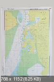
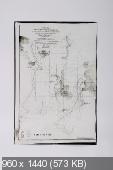
Все карты по Чемульпо
Решил собрать в одну кучу все карты по Чемульпо, разбросанные по разным форумам,сайтам и темам
Справедливо начать с английских карт №№1270,1258,выложеных, в свое время ув. Тимомом.
Итак карта №1258. Англия,1884г. Approaches to Seul
http://www.cruiserx.narod.ru/maps/map_1258.jpg
Добро — это когда я украду чужой скот и чужих жен, а зло — когда у меня украдут.

#2 02.01.2009 08:59:01
- Geomorfolog
- Вице-Адмиралъ, картографъ, лучший меценат Форума 2009 и 2011


- Откуда: г. Ноябрьск-Белая Церковь
- Сообщений: 9530
Re: Все карты по Чемульпо
Карта №1270,на ней то и построено большинство схем боя.Англия,1884г. Approaches to Chemulpo Anchorage
http://www.cruiserx.narod.ru/maps/map_1270.jpg
Добро — это когда я украду чужой скот и чужих жен, а зло — когда у меня украдут.

#3 02.01.2009 09:16:35
- Geomorfolog
- Вице-Адмиралъ, картографъ, лучший меценат Форума 2009 и 2011


- Откуда: г. Ноябрьск-Белая Церковь
- Сообщений: 9530
Re: Все карты по Чемульпо
Часть карты Восточного берега Печилийского и Ляодунского заливов и Северной части Желтого моря.Россия. Дата и масштаб,с сожалению не указаны.
http://sistematima.narod.ru/Texts/Varya … aryag1.htm
Добро — это когда я украду чужой скот и чужих жен, а зло — когда у меня украдут.

#4 02.01.2009 09:29:38
- Geomorfolog
- Вице-Адмиралъ, картографъ, лучший меценат Форума 2009 и 2011


- Откуда: г. Ноябрьск-Белая Церковь
- Сообщений: 9530
Re: Все карты по Чемульпо
А это также подходы к ЧМП. Фрагмент японской военно морской карты 1896г.
http://radikal.ru/F/i037.radikal.ru/080 … 2.jpg.html
Продолжение следует
Добро — это когда я украду чужой скот и чужих жен, а зло — когда у меня украдут.

#5 07.01.2009 12:06:00
- Geomorfolog
- Вице-Адмиралъ, картографъ, лучший меценат Форума 2009 и 2011


- Откуда: г. Ноябрьск-Белая Церковь
- Сообщений: 9530
Re: Все карты по Чемульпо
Крупномасштабная карта рейда ЧМП. 1876г. лист №71(точный масштаб по-японски,но есть хорошая масштабная линейка)
цитата:
A collection of copperplate marine charts made in the early Meiji period. The Meiji government instituted the Hydrographic Section of the Navy Division of the Department of Military Affairs in the Tsukiji district of Tokyo in 1871. In 1872, the survey ship Kasuga carried out the first modern marine survey by Japanese themselves, in the port of Kamaishi in Rikuchu Province (present-day Miyagi Prefecture). Yanagi Narayoshi (1832 - 1891), Captain of the Kasuga, hailed from the Tu clan, and was appointed to serve as the first director of the Hydrographic Department, which was established in a reorganization of the administrative setup in 1886. In one corner of the charts are noted items including position (latitude and longitude), tidal range, and the names of the survey team members. The collection contains charts that were made in the years up to and including 1878, and were published by 1879.
Owing to differences of size, a single page contains more than one chart in some cases. In the original collection, a single page measures 53 cm by 69 cm, and a two-page spread, 106 cm by 69 cm. The thirtieth entry in the table of contents (Oshima Kamise Supplementary Chart) is contained on the same page as the ninth entry (Sazara Harbor, Ise Province). In some cases, the actual order in the binding is different from that in the table of contents.
No. 19. The survey was conducted in 1873, and the chart was published in 1874.
http://radikal.ru/F/i018.radikal.ru/080 … 3.jpg.html
Добро — это когда я украду чужой скот и чужих жен, а зло — когда у меня украдут.

#6 07.01.2009 12:10:17
- Geomorfolog
- Вице-Адмиралъ, картографъ, лучший меценат Форума 2009 и 2011


- Откуда: г. Ноябрьск-Белая Церковь
- Сообщений: 9530
Re: Все карты по Чемульпо
Японская карта рейдп ЧМП. 1876-1877. М-б 1:8226.. http://radikal.ru/F/i028.radikal.ru/080 … 0.jpg.html
Добро — это когда я украду чужой скот и чужих жен, а зло — когда у меня украдут.

#7 08.01.2009 12:08:13
- Geomorfolog
- Вице-Адмиралъ, картографъ, лучший меценат Форума 2009 и 2011


- Откуда: г. Ноябрьск-Белая Церковь
- Сообщений: 9530
Re: Все карты по Чемульпо
Рейд Инчхона. 1:12 500. США. 1950. Обработана при помощи ув. vs/18
http://breeze.dnsalias.net/1.html
Добро — это когда я украду чужой скот и чужих жен, а зло — когда у меня украдут.

#8 08.01.2009 12:10:35
- Geomorfolog
- Вице-Адмиралъ, картографъ, лучший меценат Форума 2009 и 2011


- Откуда: г. Ноябрьск-Белая Церковь
- Сообщений: 9530
Re: Все карты по Чемульпо
Рейд Инчхона. 1:50 000.Верхний лист. США. 1950. Обработана при помощи ув. vs/18
http://breeze.dnsalias.net/2.html
Добро — это когда я украду чужой скот и чужих жен, а зло — когда у меня украдут.

#9 08.01.2009 12:22:01
- Geomorfolog
- Вице-Адмиралъ, картографъ, лучший меценат Форума 2009 и 2011


- Откуда: г. Ноябрьск-Белая Церковь
- Сообщений: 9530
Re: Все карты по Чемульпо
Рейд Инчхона. 1:50 000.Нижний лист. США. 1950. Обработана при помощи ув. vs/18
http://breeze.dnsalias.net/korean_war_p … _302-1.bmp
Добро — это когда я украду чужой скот и чужих жен, а зло — когда у меня украдут.

#10 09.01.2009 12:07:03
- Geomorfolog
- Вице-Адмиралъ, картографъ, лучший меценат Форума 2009 и 2011


- Откуда: г. Ноябрьск-Белая Церковь
- Сообщений: 9530
Re: Все карты по Чемульпо
Топокарта 1:250 000. Начало 1950-х. США
http://www.lib.utexas.edu/maps/ams/kore … nj52-9.jpg
Добро — это когда я украду чужой скот и чужих жен, а зло — когда у меня украдут.

#11 09.01.2009 12:09:53
- Geomorfolog
- Вице-Адмиралъ, картографъ, лучший меценат Форума 2009 и 2011


- Откуда: г. Ноябрьск-Белая Церковь
- Сообщений: 9530
Re: Все карты по Чемульпо
Топокарта 1:200 000. СССР. 1983(съемка 1973г)
http://s200.ipicture.ru/uploads/071205/TFNebe1hz3.gif
Добро — это когда я украду чужой скот и чужих жен, а зло — когда у меня украдут.

#12 30.10.2009 09:43:32
- Geomorfolog
- Вице-Адмиралъ, картографъ, лучший меценат Форума 2009 и 2011


- Откуда: г. Ноябрьск-Белая Церковь
- Сообщений: 9530
Re: Все карты по Чемульпо
Добро — это когда я украду чужой скот и чужих жен, а зло — когда у меня украдут.

#13 26.10.2010 15:09:38
- Geomorfolog
- Вице-Адмиралъ, картографъ, лучший меценат Форума 2009 и 2011


- Откуда: г. Ноябрьск-Белая Церковь
- Сообщений: 9530
Re: Все карты по Чемульпо
Карты по Чемульпо 1919г.
Карта коммуникаций Японской империи,из которой видно,что ЧМП превратился в важный транспортный узел.
Добро — это когда я украду чужой скот и чужих жен, а зло — когда у меня украдут.

#14 26.10.2010 15:11:07
- Geomorfolog
- Вице-Адмиралъ, картографъ, лучший меценат Форума 2009 и 2011


- Откуда: г. Ноябрьск-Белая Церковь
- Сообщений: 9530
Re: Все карты по Чемульпо
Добро — это когда я украду чужой скот и чужих жен, а зло — когда у меня украдут.

#15 26.10.2010 15:14:16
- Geomorfolog
- Вице-Адмиралъ, картографъ, лучший меценат Форума 2009 и 2011


- Откуда: г. Ноябрьск-Белая Церковь
- Сообщений: 9530
Re: Все карты по Чемульпо
Карта приливно-отливных течений порта ЧМП.
Помнится в свое время,по поводу влияния приливно-отливных течений на движения Варяга и особенно Чиоды было сломано немало копий.
Добро — это когда я украду чужой скот и чужих жен, а зло — когда у меня украдут.

#16 26.10.2010 15:14:59
- Geomorfolog
- Вице-Адмиралъ, картографъ, лучший меценат Форума 2009 и 2011


- Откуда: г. Ноябрьск-Белая Церковь
- Сообщений: 9530
Re: Все карты по Чемульпо
Добро — это когда я украду чужой скот и чужих жен, а зло — когда у меня украдут.

#17 23.03.2011 20:07:37
- Geomorfolog
- Вице-Адмиралъ, картографъ, лучший меценат Форума 2009 и 2011


- Откуда: г. Ноябрьск-Белая Церковь
- Сообщений: 9530
Re: Все карты по Чемульпо
Добро — это когда я украду чужой скот и чужих жен, а зло — когда у меня украдут.

#18 24.03.2011 03:06:39
- Geomorfolog
- Вице-Адмиралъ, картографъ, лучший меценат Форума 2009 и 2011


- Откуда: г. Ноябрьск-Белая Церковь
- Сообщений: 9530
Re: Все карты по Чемульпо
Добро — это когда я украду чужой скот и чужих жен, а зло — когда у меня украдут.

#19 06.01.2012 16:20:09
- Geomorfolog
- Вице-Адмиралъ, картографъ, лучший меценат Форума 2009 и 2011


- Откуда: г. Ноябрьск-Белая Церковь
- Сообщений: 9530
Re: Все карты по Чемульпо
карта приливов в заливе Чемульпо.60-е годы 20ст.
http://kosfic.chonnam.ac.kr/literature_ … count=4259
Она же с таблицами.
Добро — это когда я украду чужой скот и чужих жен, а зло — когда у меня украдут.

#20 06.01.2012 16:21:45
- Geomorfolog
- Вице-Адмиралъ, картографъ, лучший меценат Форума 2009 и 2011


- Откуда: г. Ноябрьск-Белая Церковь
- Сообщений: 9530
Re: Все карты по Чемульпо
Добро — это когда я украду чужой скот и чужих жен, а зло — когда у меня украдут.

#21 07.01.2012 07:55:24
- Geomorfolog
- Вице-Адмиралъ, картографъ, лучший меценат Форума 2009 и 2011


- Откуда: г. Ноябрьск-Белая Церковь
- Сообщений: 9530
Re: Все карты по Чемульпо
Добро — это когда я украду чужой скот и чужих жен, а зло — когда у меня украдут.

#22 07.01.2012 08:16:26
- Geomorfolog
- Вице-Адмиралъ, картографъ, лучший меценат Форума 2009 и 2011


- Откуда: г. Ноябрьск-Белая Церковь
- Сообщений: 9530
Re: Все карты по Чемульпо

Современная карта подходов к Инчхону. К сожалению уменьшена.Впрочем расстраиватся нечего. Гидрографическая и навигационная обстановка насколько изменилась за 100лет,что анализировать по ней знаменитый бой просто бессмысленно.
Добро — это когда я украду чужой скот и чужих жен, а зло — когда у меня украдут.

#23 19.04.2012 14:46:20
- Geomorfolog
- Вице-Адмиралъ, картографъ, лучший меценат Форума 2009 и 2011


- Откуда: г. Ноябрьск-Белая Церковь
- Сообщений: 9530
Re: Все карты по Чемульпо
Добро — это когда я украду чужой скот и чужих жен, а зло — когда у меня украдут.

#24 20.04.2012 09:48:24
- Geomorfolog
- Вице-Адмиралъ, картографъ, лучший меценат Форума 2009 и 2011


- Откуда: г. Ноябрьск-Белая Церковь
- Сообщений: 9530
Re: Все карты по Чемульпо
Добро — это когда я украду чужой скот и чужих жен, а зло — когда у меня украдут.

#25 12.08.2012 17:51:18
- Novik1900
- Гость
Re: Все карты по Чемульпо
Страниц: 1 2
- Форум
- » Картографический отдел
- » Все карты по Чемульпо


